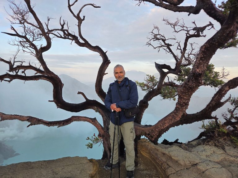
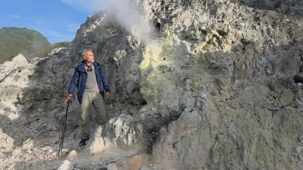
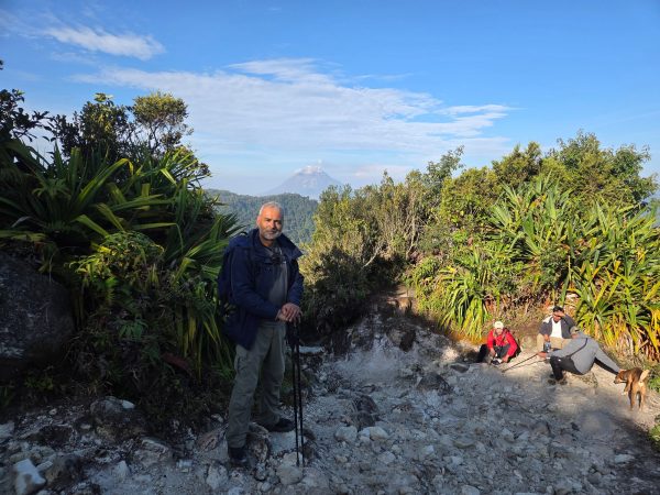
A few days ago, in March 2026, I hiked up Sibayak on a sprained ankle. A dramatic sprained ankle, and a sprain that made itself known on every uneven step. The irony is that this barely qualifies as a hike. The trail from Berastagi to the summit is about seven kilometres, the path is largely clear, and the whole thing takes most people around three hours without pushing. It is, by the standards of active volcanoes anywhere in the world, a walk in the park. The crater at the top is spectacular. The sulphur smell hits you well before you see the vents. And standing at the rim looking down at the turquoise-tinged crater lake with fumaroles hissing around you and the town of Berastagi visible below, you start to appreciate something that the postcard version of this place does not quite convey.

The town of Berastagi is not at the foot of Sibayak. It is inside the Singkut caldera, on the flat-floored depression left by an older eruptive event, with the younger cones of Sibayak and its twin Pintau rising directly from the southern rim above it. The town, the fruit market, the flower stalls, the cool highland air that draws visitors up from Medan on weekends, all of it sits inside a volcanic structure. The distance from the town centre to the active fumarole fields on the summit is a matter of kilometres. In volcanic terms, that is essentially the same address.
The story of how this landscape came to exist begins not with Sibayak but with the plateau it sits on. The Karo highlands of North Sumatra are one of the more volcanically active regions in Indonesia. The Indo-Australian Plate is grinding beneath the Eurasian Plate along the Sunda Arc, driving magmatism across a volcanic chain that runs the length of Sumatra. But the Karo plateau carries an additional complication: the Great Sumatran Fault, a major strike-slip structure running the entire length of the island, which partitions the tectonic strain and creates a local geological environment considerably more complex than straightforward arc volcanism. Then there is the matter of what happened here approximately 74,000 years ago, when the Toba caldera complex, roughly 100 kilometres to the southeast, produced the largest eruption on Earth in the past two million years. The Youngest Toba Tuff eruption ejected a minimum of around 2,800 cubic kilometres of material. It blanketed the Karo plateau under pyroclastic deposits that in places reached hundreds of metres thick. The soils the Karo Batak people farm today, some of the most fertile in Sumatra, are in significant part the weathered product of that catastrophe. The vegetables in the Berastagi market have grown in Toba ash. That is the ground everything here is built on, literally and geologically.

The Singkut caldera formed through an eruption earlier than all of this, its roughly seven by four kilometre depression subsequently filled by post-caldera volcanic activity. Sibayak grew on the southern rim of that structure, an andesitic stratovolcano reaching approximately 2,212 metres, its 900-metre-wide summit crater partially overtaken by the slightly higher Pintau cone to the north. A lava flow passed through a gap in the western crater wall at some point in the past, evidence of effusive activity from the summit dome. The caldera floor to the southeast became the site of villages and agricultural land, and eventually, Berastagi.
The magma that built Sibayak belongs to a high-potassium calc-alkaline series, andesitic to dacitic in character, which is consistent with a mature continental margin arc setting. But geochemical analysis of volcanic rocks from the broader Kabanjahe region reveals something more interesting than standard arc chemistry. Published work shows notably high niobium concentrations in local lavas, a signature more typical of intraplate volcanism than conventional subduction-zone output. Part of the explanation may lie in the granitic basement of this region, belonging to the Mergui microcontinent, which influences how magma evolves as it rises through the crust and contributes to the strongly acidic character of the volcanic products across the plateau. Fractional crystallisation of plagioclase, clinopyroxene, hornblende, and biotite drives much of the compositional range from more mafic to more evolved compositions, a process that leaves chemical fingerprints in the rocks and minerals that accumulate in the magma body as it matures.

Zircon is the mineral that volcanologists use to read those fingerprints most precisely. It crystallises preferentially in cooler, more evolved silicic magmas and survives reheating and recycling within a magma system, preserving isotopic and chemical records that can span hundreds of thousands of years within a single grain smaller than a grain of sand. The great contribution of zircon studies to understanding Sumatran volcanism has come primarily from Toba, where researchers have found evidence for near-continuous zircon crystallisation over at least 1.6 million years, reflecting the slow and protracted assembly of that colossal magmatic reservoir beneath the same plateau Sibayak sits on. Whether any subsurface connection exists between the Toba system and the more modest plumbing beneath Sibayak is not established in the literature. Both draw on the same tectonic setting, the same crustal basement, and the same broad heat source. The question of how much these systems communicate at depth remains genuinely open.
What is better established is the relationship between Sibayak and its more immediately dramatic neighbour, Sinabung, roughly 30 kilometres to the southwest. Both are Holocene volcanoes on the Karo plateau. Both are back-arc in character relative to the main Sumatran volcanic front. And they are connected, at least structurally, by a northeast-southwest sinistral fault zone that runs between them at shallow depth. Research published in Geoscience Letters in 2025, using seismic tomography, satellite radar interferometry, and gravity data, identified evidence for a blind fault in this inter-volcano zone, a structure concentrated at one to five kilometres depth, inferred from earthquake swarms that clustered between the two edifices before Sinabung’s largest eruption in February 2018. Earlier work by Hendrasto and colleagues in 2012 had already described this fault lineament based on the spatial distribution of volcanic seismicity. Sinabung formed at the southwestern end of this fault system. Sibayak formed at the northeastern end. They are not the same volcano. But they are not entirely independent either, and when Sinabung stirred in 2010 after roughly 1,200 years of dormancy, elevated steam activity and increased sulphurous emissions were reported at Sibayak in the period that followed.
Sibayak’s own eruption record is short. The only confirmed historical eruption occurred in 1881, documented as ash clouds reported by Hoekstra and cited in the scientific literature by Neumann van Padang in 1983. The Karo Batak oral tradition preserves memories of other eruptions, suggesting the 1881 event was not the only one within living cultural memory, but pre-historical eruptive activity is not well constrained in the published record. What the volcano’s physical form makes clear is that its geological history is longer and more eventful than its documented eruptions suggest. The lava dome, the crater depression, the altered rocks, the lava flow through the western crater wall, none of these were produced by a single moderate ash eruption in the nineteenth century. They represent accumulated volcanic work over a much longer timescale.

Beneath the surface, the heat is ongoing and measurable. Sibayak hosts the first commercial geothermal field developed in Sumatra, with a liquid-dominated hydrothermal reservoir reaching temperatures of up to 280 degrees Celsius. Ten production wells extract around 25 megawatts of electrical capacity. Toba tuff deposits extend 300 to 500 metres below the surface across the Berastagi area, with volcanic rock beginning at approximately one kilometre depth according to geothermal well logs. A reservoir at 280 degrees Celsius is not a relic of past heat. It is an active system, sustained by an ongoing magmatic source at depth, and it is the same source that drives the fumaroles you smell from the town, the hot springs on the flanks, and the discoloured crater lake at the summit that tourists photograph and swim near without always understanding what it represents.

The more immediate hazards Sibayak poses are not magmatic. Nothing in the current monitoring record from PVMBG suggests the volcano is building toward a large eruptive event. The hazard that deserves attention is phreatic, eruptions driven by the superheating of groundwater within the hydrothermal system, which can occur without extended precursors and can produce ballistic projectiles, sudden toxic gas releases, and acidic flows from the crater lake if the crater wall is destabilised by ongoing hydrothermal alteration.
I stood at the crater rim in March with my ankle complaining and watched the fumaroles rise into the cold highland air, and across the plateau I could just make out the shape of Sinabung to the southwest. Two volcanoes connected by a fault neither of them chose, in a landscape built on the ruins of an eruption so large it changed the climate of the planet. The Toba ash is in the soil. The heat from whatever lies beneath Sibayak is in the wells. The fault between the two volcanoes is in the rock, invisible from the surface, detectable only by instruments that listen to the ground.
Sibayak has not erupted since 1881. That is not quite the same as saying it has been quiet.
Copyright © Tales from the Horizon, 2025